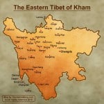
Located in the Western Sichuan and Northwest Yunnan province. It has a rugged terrain characterized by

mountain ridges and gorges running from northwest to southeast. The nonthern and western Kham consist most high altitude grasslands that are above 4000m. The southern Kham has numerous rivers, including the Mekong River, Yarlung River, and the Salween River flow through, which form lands and weather allowing Tibetan farmers to grow barley, wheat , and other vegetables and fruit trees. The eastern Kham is between 2500m – 3500m, are covered in thick evergreen forests. Snow-capped, glaciated peaks can be viewed almost everywhere. The higest mountain is Mt. Minya gangkar (7556m), which is also a wonderful site for making treks. from 5 days trekking to 111days trekking, this enormous region holds a large range of different treks, as well as Kawa Karpo;
Kham was also the home of many early Repoches, lamas, including the founders of the Drigungpa and Karmapa. Derge, a historic site that also provide numberous off-the-beaten path to visit, such as Palpung monastery, Dzongsar monastery…etc;
The bright part is – for the most of Kham are open, you may choose to travel with a tour operator, either way on your own, if you think you are able to get over the difficults of arranging traffic and laguage barrier. and It is true that Kham is one of the best places to observe traditional Tibetan culture, which we do agree! The best preserved Tibetan culture, very few travelers, almost no tourist, colorful nomad culture, different tradition of monastery. This is a wonderful place to visit;


Leave a Reply